Understanding the Role of Coastal Forests in Disaster Risk Reduction in Demak, Central Java
The Mathematics of Risk, Understanding Disaster-Risk Reduction
In an era increasingly defined by climate crisis and coastal degradation, the intersection between nature and disaster-risk reduction (DRR) has become more than just a technical agenda, it is not just an abstract concept for scientists and planners, but it is a living, it is existential, breathing framework that determines the future of coastal communities, it is a survival strategy. At its core, DRR aims to prevent or minimize the damage caused by natural hazards through proactive planning, ecosystem-based strategies, and community resilience. The Sendai Framework Terminology on Disaster Risk Reduction defines Disaster risk as the potential loss of life, injury, or destroyed or damaged assets which could occur to a system, society or a community in a specific period of time, determined probabilistically as a function of hazard, exposure, vulnerability and capacity. The definition of disaster risk reflects the concept of hazardous events and disasters as the outcome of continuously present conditions of risk. Disaster risk comprises different types of potential losses which are often difficult to quantify. Nevertheless, with knowledge of the prevailing hazards and the patterns of population and socioeconomic development, disaster risks can be assessed and mapped, in broad terms at least. In Demak’s coastal context, the disaster risk profile is intricately shaped by the dynamic interplay between these core elements that together determine the magnitude and impact of disasters faced by the community. Its real-world complexity unfolds in places like Demak, Central Java, Indonesia, this equation isn’t just theory, this intersection is vividly real. It defines everyday life, where mangrove forests once stood as a living firewall against storms, erosion, and sea-level rise, once pushed to disappear and are now being brought back into the equation of survival.
In this low-lying district fronting the Java Sea, hazards such as cyclonic storms, tidal floods, coastal abrasion, and saltwater intrusion are natural phenomena, yet their impacts are determined by the interaction of exposure, vulnerability, and capacity. Exposure refers to the situation of people, infrastructure, housing, production capacities and other tangible human assets located in hazard-prone areas. With over 1 million residents, extensive rice fields, densely settled coastal zones, and a rapidly urbanizing coastline, Demak’s exposure is alarmingly high. But what turns a hazard into a disaster is vulnerability, defined as the conditions determined by physical, social, economic and environmental factors or processes which increase the susceptibility of an individual, a community, assets or systems to the impacts of hazards. When people settle in unsafe areas (high exposure), as land subsidence (up to 10 cm/year in some areas), limited infrastructure, and socio-economic precarity heighten susceptibility to hazards (high vulnerability), the risk multiplies.
Yet the equation does not end there. What determines whether exposure and vulnerability translate into devastation is the capacity of people and systems to anticipate, absorb, adapt, and transform in the face of hazards. Capacity functions as an inverse of vulnerability.
In Demak, this capacity increasingly takes the form of Ecosystem-based Disaster Risk Reduction (Eco-DRR), defined as the sustainable management, conservation and restoration of ecosystems to reduce disaster risk, to achieve sustainable and resilient development (UNDRR & UNEP, 2020). Capacity emerges through community-based mangrove restoration, hybrid engineering of permeable structures to attenuate waves and trap sediments, institutional support from government and NGOs, and the ecological resilience of coastal ecosystems. These capacities reduce effective disaster risk by buffering hazards and limiting the extent to which exposure and vulnerability translate into disaster outcomes. Here, mangrove restoration and hybrid coastal engineering are deployed not only to buffer waves, trap sediments, and slow coastal abrasion, but also to support local livelihoods and diversify income. These ecological measures enhance resilience more effectively than concrete walls alone, because they reduce hazard impacts while simultaneously lowering vulnerability and strengthening adaptive capacity. Thus, reducing risk demands ecological, social, and systemic resilience. The Intergovernmental Panel on Climate Change (IPCC AR6, 2022) further confirms that coastal ecosystems such as mangroves, seagrasses, and wetlands provide significant risk reduction benefits, making Eco-DRR a cornerstone of climate-resilient development.
In this sense, the mangrove ecosystem in Demak has played out dramatically over the last few decades as mangrove degradation collided with rapid coastal development and climate variability. It embodies Eco-DRR in practice: rooted in mud, offering protection, resilience, and hope, the mangrove ecosystem is growing as a solution, it rises against the tides, holding ground where concrete crumbles, a living shield that protects, sustains, and whispers resilience at the meeting point of land and sea, the very expression of capacity in practice, and this is where mangroves enter the equation.
What Are Mangroves and Why Do They Matter?
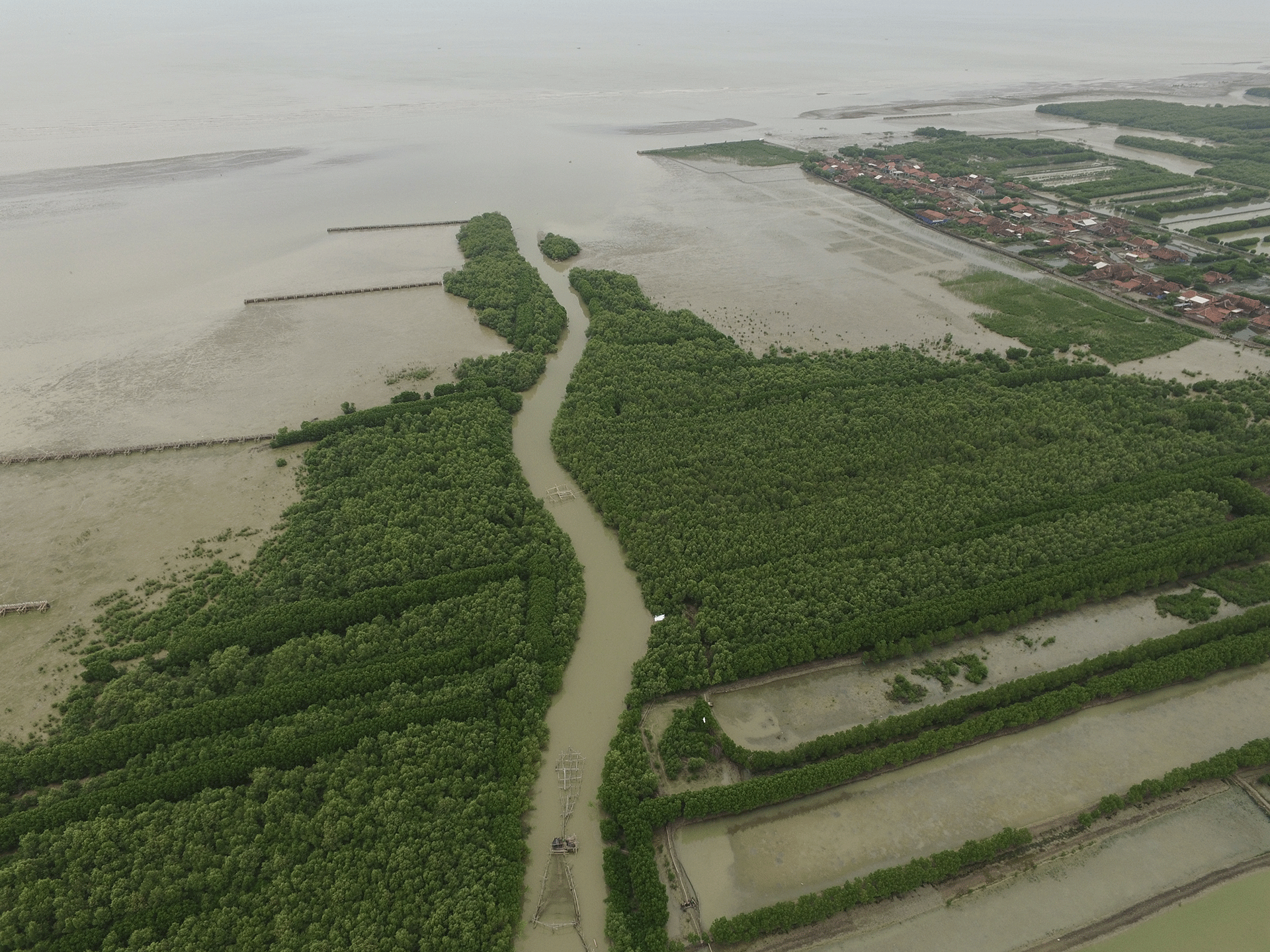
Mangroves are salt-tolerant trees and shrubs that thrive in intertidal tropical and sub-tropical coastal areas. In Demak, these ecosystems, dominated by species such as Avicennia marina, Rhizophora mucronata, and Sonneratia caseolaris, used to stretch across the coastline, form green fortresses along the coast, sheltering villages and nurturing a cradle of life for aquatic species and a buffer zone for inland communities.
To most people, they may appear as simple trees, but from a DRR lens, mangroves are bio-engineers, buffer zones, and social lifelines. Their dense roots trap sediment, stabilize the shoreline, dissipate wave energy, filter pollutants, and serve as nurseries for fish and crabs. They are a natural infrastructure whose services, if valued appropriately, are worth millions of dollars per hectare per year.
Beyond their physical presence, mangroves provide key ecosystem services categorized into provisioning, regulating, and cultural services. Ecosystem services from mangroves in Demak are multifaceted, mangroves are nature’s multitaskers. Provisioning services include fuelwood, honey, fish, and increasingly, mud crab (Scylla serrata) aquaculture integrated with mangrove restoration. Local honey production from mangrove blossoms is on the rise, as is the revival of herbal uses of Bruguiera bark and Acanthus ilicifolius leaves that directly support local livelihoods. Small-scale fishers and gleaners, particularly women, rely heavily on the productivity of these areas. In Demak, silvofishery systems, a hybrid of aquaculture and mangrove conservation, demonstrate how livelihoods can be sustained without destroying the ecosystem.
Regulating services are even more critical in a DRR context and perhaps the most undervalued. Mangroves sequester carbon (more than one in inland forest, in biomass and soil combined), act as windbreakers, and reduce the speed and energy of incoming waves and storm surges. During high tide or coastal flooding events, mangrove belts reduce inundation depth and velocity, lessening the destructive force on villages behind them. A 2022 simulation showed that healthy mangrove belts can reduce wave height by up to 60% and delay peak storm surge inland by nearly 30 minutes, valuable time for evacuation.
Meanwhile, cultural services, including spiritual values, ecotourism, and educational uses, are often overlooked but deeply significant, and increasingly recognized. In Demak, traditional knowledge recognizes mangroves as spiritual guardians (penjaga pantai) and ecological teachers. Local communities in Demak maintain traditional knowledge and practices for rehabilitating and protecting mangroves, often passed down through generations. Festivals, folklore, and rituals associated with the sea and the forests reflect a cultural identity intimately tied to the coastal landscape.
A Historical Overview from Abundance to Loss, and Back Again
Historically, the coastline of Demak wasn’t always this fragile. Up until the early 1980s, the region was characterized by dense mangrove belts, traditional fisheries, and balanced ecological systems. This era of abundance was sustained by low population pressure and limited infrastructure development. Satellite imagery and local archives reveal that more than 2,000 hectares of mangroves once spanned the district’s coast, coexisting with sustainable aquaculture and low-impact settlements. This period could be called the era of abundance and ecological balance. However, starting in the 1980s and accelerating through the 1990s and 2000s, this balance was upended, and a cascade of changes occurred.
Driven by economic incentives, extensive conversion of mangrove areas into shrimp ponds (locally called tambak) occurred, coupled with poorly planned infrastructure, triggering a chain reaction. The government’s push for aquaculture development in the post-Green Revolution era saw thousands of hectares of mangroves cleared. Coastal erosion and poorly regulated pond construction and operation led to ecological degradation, rapid coastal erosion, and eventually, pond abandonment. Without root systems to bind sediment, coastal erosion accelerated. Combined with groundwater over-extraction leading to land subsidence, the coastline began to retreat, and some settlements were lost to the sea.
By 2000, Mangrove coverage had plummeted, nearly 80% of the original mangrove forests had been lost, and the coast began to retreat rapidly. Data from the early 2010s indicate that damage to mangroves in Demak rose from 8% in 2011 to almost 14% by 2012, directly correlating with increased coastal erosion rates of 2- 3 centimetres per year and shoreline retreat between 1 and 1.5 kilometres in some areas. This environmental degradation exacerbated “rob” flooding, tidal inundation, which further threatened the exposure and vulnerability of Demak’s coastal settlements.
The 2010s marked a period of ecological alarm and awakening. Tidal flooding intensified, school buildings collapsed into the sea, and some kampong/sub-villages began relocating inland. Demak had become a case study of coastal vulnerability where over 2 km of coastline had retreated inland, swallowing not only ponds but also roads, schools, and homes.
In response, then came the turning point. In 2015, a consortium of actors, ranging from Government institutions, local communities to NGOs like Wetlands International and research institutes launched pioneering nature-based solutions initiatives like Building with Nature Indonesia. Rather than relying solely on concrete sea walls, these initiatives focused on hybrid engineering solutions, combining permeable brushwood-bamboo dam structures to trap sediment and re-establish natural buffers, stimulate mangrove regrowth naturally, and combine with community-based livelihood restoration. The aim was not merely rehabilitation, but resilience.
In the nexus of hazard, exposure, vulnerability and capacity, the restoration and conservation of mangroves in Demak translates directly to disaster risk reduction achievements. By the early 2020s, signs of ecological recovery emerged in some villages. In Betahwalang and Wedung, mangrove regrowth now blankets areas once barren. Crab catches have improved. Youth groups are organizing eco-tourism trips and managing mangrove nurseries. This is the era of scaling up restoration and resilience.
Linking DRR Components with Mangrove Services in Demak
How do mangrove ecosystem services directly intersect with hazard, exposure, vulnerability and capacity? Let’s revisit the DRR equation and examine how mangrove ecosystems in Demak respond to each element.
First, Hazard Mitigation. Mangroves don’t eliminate hazards, but they moderate their physical impact. They slow the wave energy, reduce the inundation extent, and stabilize coastlines against erosion. A study by van Wesenbeeck et al. (2017) in Demak found that restored mangroves reduce wave energy by 20- 50%, depending on density and structure. Their roots bind sediment, raising land elevation over time and countering land subsidence.
Second, Reducing Exposure. Mangroves increase the buffer zone between the sea and human settlements. In some cases, well-designed mangrove buffers can physically separate hazard-prone zones from human settlements, minimize exposure by protecting infrastructure, farmlands, and settlements from encroaching seas, thus preventing further displacement of communities. In Demak, green belts act as “no-go” zones for construction, indirectly encouraging relocation of settlements to safer inland areas. Mangrove zones also reduce saltwater intrusion into agricultural lands, preserving freshwater and food systems.
Third, improving Capacity and lowering Vulnerability. Perhaps most importantly, mangroves strengthen social-ecological resilience, reduce socio-economic vulnerability by supporting food security, offering alternative income, and enabling local adaptation through nature-based solutions, thus improving capacity. They support livelihoods, diversify income sources (e.g., mud crab farming), and foster community-based management institutions. With proper training and tenure clarity, local communities are no longer passive victims of disaster, but active managers of their landscapes.
But challenges remain. Population pressure, illegal use of mangroves, inconsistent enforcement, unclear tenure rights and limited long-term financing mechanisms threaten the sustainability of progress. Public and private sector collaboration is vital. As of 2023, national initiatives like the Mangrove Rehabilitation Program (MRP) under the Peat and Mangrove Restoration Agency (BRGM) have aligned with Demak’s local agenda, offering both funding and technical support. However, long-term sustainability hinges on integrating mangrove restoration into spatial planning, education curricula, climate policy, and community empowerment programs. Ensuring sustainability requires embedding mangrove conservation in spatial planning, local laws, education systems, and private sector incentives, especially through blue carbon markets and insurance instruments.
The Bigger Picture from Demak to the World
Demak’s journey is far from over. While Demak is unique and universally instructive in its hydrological, social, and historical context, it is also a microcosm of global challenges and solutions. The triple threats of climate change, ecosystem degradation, and coastal overdevelopment are playing out in Mexico, Guinea-Bissau, and beyond. Demak’s approach, of blending government leadership, use of local knowledge, science, policy innovation, and community engagement, offers a model for global learning. It proves that mangroves are not simply trees, but they are bio-shields, carbon banks, culture bearers, and allies in the fight for climate resilience. They blur the line between land and sea, between ecology and economy, between science and spirit. For Demak, they are not a luxury, they are survival. In a time when sea levels rise faster than policies adapt, Demak tells a story of how nature can lead, if humans are willing to follow. It shows how hybrid solutions, combining engineering, ecology, and community empowerment, can restore not only landscapes but livelihoods. It reflects national priorities, such as Indonesia’s Presidential Decree No. 120/2020 on mangrove rehabilitation, and offers insights for global DRR strategies under the Sendai Framework and the Paris Agreement. This has also attracted international interest in documenting Eco-DRR initiatives, such as the documentation of Eco-DRR Heritage in wetlands supported by Keidanren Japan. Documentation of good practices was also carried out by the Wetlands for Resilience (W4R) initiative supported by the Government of Sweden through SIDA and the UN Decade Targeted Support (UNDTS).
The sustainability of mangrove rehabilitation in Demak depends not only on continued funding but also on governance structures that empower communities, ensure transparency, and align public and private sector efforts. As of 2024, the Central Java provincial government has integrated Building with Nature principles into its coastal spatial plans, and national programs like the “Mangrove for Coastal Resilience” (M4CR) initiative now reference Demak as a flagship site.
Mangroves as Mathematics of Hope
The future of Demak’s coastlines will not be decided by concrete alone, but by whether we can solve the risk equation with the tools nature has already given us. Mangroves are not a panacea. But in the coastal math of disaster risk, they are a multiplier of resilience. Mangrove reduces hazards, lowers exposure, and empowers communities to tackle vulnerability head-on. In a world racing against climate collapse, the muddy forests of Demak may yet prove to be among our most intelligent investments.
The tide may be high, but with roots deep in science, community, government and policy, the mangroves of Demak stand as a living reminder that resilience is possible, and it begins at the edge of land and sea. In a world increasingly haunted by the consequences of ecological ignorance, the lesson from Demak is urgent and clear that working with nature is not just a philosophy, it is a necessity. The time to scale up, replicate, and protect what works is now. Before more land sinks, before more lives are lost, before the tide becomes irreversible.
Diramu oleh: